
It might not seem like that much – say, 5,000 square feet, the size of an average city lot in Seattle. But when you look at what once was living there and the current deadness of the space surrounded by a vibrant forest, well…
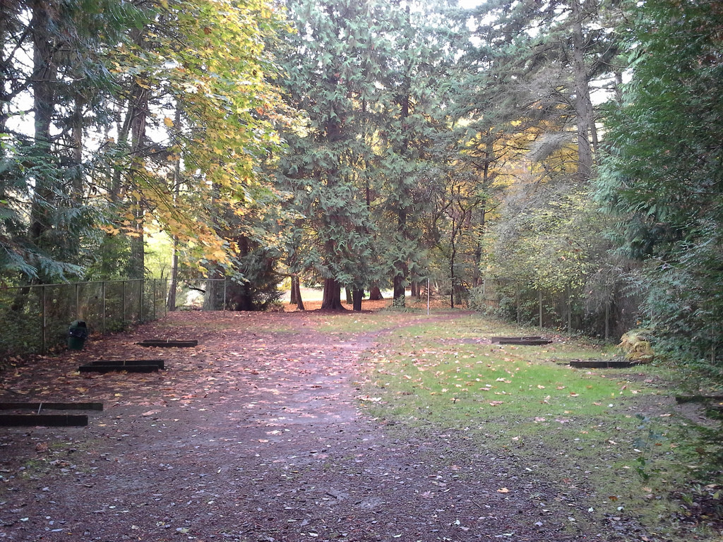 This horseshoe pit in Lincoln Park was built in the mid 1930’s by the WPA. It has not been used regularly in decades. Its most frequent activity these days is a weekend beer party in the summer. See over 100 pictures taken there in the last eight months. There are six trees growing within its chain link fences: a western red cedar, two douglas firs, and three hazelnuts. They are all at least three years old. The forest would like this space back. It should be replanted with native plants and trees, 40 concrete slabs should be dug up and hauled out, 200 feet of chain link fence should be removed, and the forest should be allowed to heal. The tree roots reaching out for each other from either side should be allowed to touch – and intertwine with the youngsters already starting to grow there.
This space is a prime candidate for mitigation – a paying pack for, or a making up for – the “development” of an undeveloped area for recreational use. Here’s an example: the Cheasty Greenspace Bike Park. If proponents for that plan get their way with the development of nearly three miles of mountain bike trails and jumps in an undeveloped natural area – they will take away at least 50,000 square feet of vegetation. It will be made into trails, paths, jumps, and ramps – which will never support any living thing.
 50,000 square feet – that’s TEN of those horseshoe pits.
To mitigate the loss to the Cheasty natural area, I propose this: replant, reforest, and naturalize the horseshoe pit at Lincoln Park – and another 45,000 square feet of “developed” but currently unused potential natural areas.
Can’t find another 45,000 square feet of developed areas to replant and remake into natural areas? Then Cheasty does not lose any area to “development”. No mountain bike park.
This example might seem extreme, but I believe it is timely, and it speaks to the conversations going on all over in Seattle right now about protecting and maintaining our natural areas. And it’s not extreme. It’s fair.
This is the proposal: no net loss to natural areas in our parks system. The bleeding must stop. If a recreational area is to be built in an undeveloped part of our parks – then exactly the same amount of a previously developed area must be returned to a natural area.
It’s called mitigation, and it’s way past time for it in our park system.
More to come – and it’s not just limited to our parks. – Mark

Thank you for putting into words what we all want to say, what we all feel, and doing it so well. It inspires hope and some comfort.
Cass, thanks for your note and your inspirational work. Next up: private holdings and other city lands (like the Myers parcels)
Cass here, again. Along the same lines, I’ve drafted a referendum to make the City legally responsible for meeting its open space goals including some automatic financing mechanisms.
Changes to the building codes and the profit motive are already overfilling our density goals. But where is the promised infrastructure, including green infrastructure that was going to make it humane? Wanna see it?
Sure! Is it online and ready for all eyes? If so, post a link. Otherwise, shoot me an email.
Mr. Ahlness,
May I ask how you are coming up with 50,000 square foot of vegetation loss? Using the USFS 2007 trail building guidelines (the USFS adopted the IMBA trail guidelines in 2007 as their standard) the total non-vegetated area (treadway) for 3 miles of trail would be 23,760 ft2. That number assumes maximum cut and maximum width, which would be hard to sustain over 3 miles of trail.
Just wondering what factors you used in determining that number.
I’m not the only one to independently arrive at 50,000 square feet – wrote about it last March. Yours is the first questionning I have seen of that figure. While that original plan is still on the table, some are now talking about dual use trails and adding walking trails cutting through the interior. 50,000 would be extremely conservative, given those proposals. But really – I don’t think it matters whether it’s 25k or 75k sq ft. It’s still vegetation and habitat loss that, to my mind, needs to be mitigated, in the way I described above. – Mark
I’m just wondering about the methodology, not the idea of mitigation.
Are you referring to construction impacts or impacts during revegetation? That should have been my first question, sorry. That might change things.
What side slope, backslope, bench widths and revegetation factors are you using?
I see no posts older than May of 2014. Am I missing something?
Cuyler,
I’m happy to see your issue is not with mitigation, which is the crux of the post.
I’ll be happy to respond to your concerns about measurement methodology. The math is pretty simple. A three foot wide trail for three miles is nearly 46,000 square feet. Yes, the IMBA guidelines might say 2 foot wide trails, but that’s unrealistic, in my opinion. Look at that picture above. It’s from Duthie Hill – widely cited as a great mountain bike trail example. I do not see any two foot wide trails in that slop. And don’t forget the jumps, ramps, etc. in the “skills” area. Plus, now people are talking about dual use trails. And exclusive use walking trails through the interior. Seattle Parks will set the widths of those walking and dual use trails, not the IMBA. Four feet is the generally accepted minimum width for maintained walking trails in Seattle Parks. Dual use trails – at least six feet.
Finally, you are right, posts on Seattle Nature Alliance only go back to May. I was referring to writing I did on my personal blog, Acrovision. I started writing about Cheasty in March, 2014, with A Tale of Two Cheasties, read by over 1,500 people. The first mention I made of the 50k square feet was in Ziplines, Mountain Bikes, and Horseshoes, published shortly after that in March and widely read. It was also the first time I mentioned the ancient horseshoe pit in Lincoln Park.
As I said before – the important question is whether we mitigate the loss of undeveloped areas by returning previously developed areas to natural areas. Quibbling over the exact square footage is at best distracting.
I was going to show how to calculate trail impacts, but I decided to take that process and make a spreadsheet of it. I will share it with you when I get it finished.
Two things though.
First, your description and picture of what is being proposed at Cheasty is not current. The pictures you are using for reference in to what mountain biking trails look like at Cheasty are misleading, at best. The above pictures are free-ride expert areas, which usually make up less than 10% of length for an ENTIRE trail system, should you even include something like that (most places won’t, especially inside a woods). In the case of Cheasty, the Seattle City Council and the PAT have already made clear those type of trails are not part of the package anymore, they were the interior trails in the original proposal. (Not sure whose bright idea it was to include them in the first place.) The trails that are being discussed are what are called “cross county” trails in the biz, they would look more like this: http://nw-trail.org/files/imagecache/product_full/IMG_3721.JPG
Second, your mitigation idea, its good, but not going to happen in its current form. No city in their right mind would go with that idea. Its a mandate without a way to pay for it. A modification you could make that a city would go with would be to make park dedication fees apply to ALL new buildings and development, regardless of size (they usually only apply to new platted developments). Say 1% of property value for residential and 2% of property value for commercial property. Hence, that new house and that new big box store are both on the hook to mitigate for their existence. Then have a large percentage of that fee go to buying current land to create contiguous natural areas that are covered by conservation easements. The advantage of these modifications to your idea are that a) it goes after the real reasons for habitat loss and b) using percentages means it automatically adjusts for inflation and property values.
While the funding process is different, here a place doing pretty much what your propose for Seattle: http://www.minnehahacreek.org/projects-capital-projects/current-projects/minnehaha-creek-urban-corridor-restoration
Cuyler, first off, a thank you for the engaging and constructive conversation. I’ve been in a few recently that were not so.
As for the Cheasty mountain bike park proposal – well, I feel pretty much done with that. I know people are saying it’s different now – but the proponents have not changed the proposal, and they are still drumming up support for a mountain bike park, complete with free ride areas. I have researched, followed, and written about this story for a very long time. I used it as an example of the loss of a natural, undeveloped area that should be mitigated – because I knew it so well – as I do the horseshoe pits area. I’d suggest you save your energy on trail widths for somebody who could put your research to good use, like those in charge of the Cheasty PAT.
On mitigation, I hear what you are saying, I get it. Frankly, I don’t care. If a resolution or mandate or whatever, got an old growth cedar trunk jammed into the gears of the city development clockworks – that would be a good thing.
Yes, I get fines – but they are not the answer. Investors have money dripping off their lips and will happily pay big fines for a chance to make huge returns on their investments. When just a small portion of those fines go into a fund, with administrative costs and huge overhead because of a newly created layer of bureaucracy – well, there’s just not left to fairly mitigate the original loss of an undeveloped area.
You said “Its a mandate without a way to pay for it.” I agree. So…
Set the mandate.
Stop the development of undeveloped, natural areas.
No money from Parks to pay for mitigation? Then they they do not get to “develop” natural areas.
Period.
I’ll talk about other city and private land in part 2 (bet you can’t wait – ha). City government and the how to’s – part 3. Best – Mark
ps – I grew up in MN – Staples and Austin. Good folks, beautiful country, some real forward thinkers there…